GRASSROOTS MAPPING:
Creating a participatory map-making process centered on discourse
by Public Laboratory for Open Technology and Science
Shannon Dosemagen, Jeffrey Warren and Sara Wylie
Introduction
“This is new. It has to do with sharing ideas and open communication – it isn’t closed like a lot of design ideas-
and you get to be out here, actually interacting with the physical world.”
-- Ray Cha, community member - Gowanus Canal Public Lab. (Brooklyn Eagle, January 2011)
In the year following the oil spill in the Gulf of Mexico, concerned residents, scientists and members of the Public Laboratory for Open Technology and Science (PLOTS) teamed up to collect over 100,000 images from regions impacted by the spill that contributed to over 80 maps of the coastline before, during and after the oil spill hit. The photos were taken as part of the Grassroots Mapping project using an inexpensive technique which requires only string, a helium balloon and a cheap digital camera. Since then, PLOTS has been working with coastal residents to disseminate and leverage the new information the maps provide, for example using them to articulate and document residents' hopes for restoration and recovery of the coastal environments, economies and ecosystems. Based on the success of the Grassroots Mapping techniques in providing an alternative look at the Gulf spill, PLOTS decided to incorporate as a non-profit, with the goal of improving the balloon mapping approach, and developing new affordable tools for DIY environmental research. In the summer of 2011 we received $500,000 from the Knight Foundation’s "News Challenge" to fund three years of research and expanded community work. Over the last year, PLOTS projects and chapters have sprouted up in new places such as the Gowanus Canal Superfund site in Brooklyn; Butte, Montana; Somerville, Massachusetts and there are plans for a new group to launch in Austin, Texas in coming months (are you interested? Send a message to team@publiclaboratory.org). These ‘labs’ are researching a range of environmental and social justice issues using our existing tools while simultaneously developing new low cost, open source tools for a more participatory civic science which is directed and owned by communities.
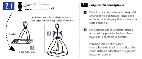
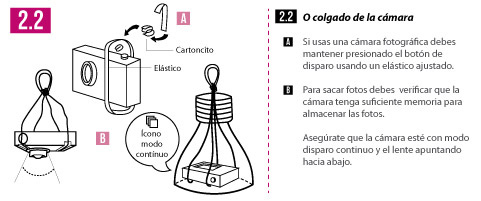
Partnering with the Gowanus Canal Conservancy and the Gowanus Dredgers Canoe Club, PLOTS has been working with activists and residents at the canal, which was declared a Superfund cleanup site in 2011. There, a diverse group has begun to produce aerial surveys of the canal prior to the start of major cleanup operations, which are currently expected to begin in 2014. Most recently, drawing inspiration from Natalie Jeremijenko's 2004 BIT Balloon project in NYC, balloon mapping "went live" when protesters in Chile combined it with streaming video to broadcast live documentation of their street protests to online audiences (http://publiclaboratory.org/place/santiago-chile). Based on these promising starts, PLOTS has begun work on other novel and affordable research tools for investigating environmental health and justice issues: a thermal camera for assessing insulation and detecting thermal pollution, a variety of spectrometric techniques for identifying contaminants, as well as tools for cheaply identifying and understanding indoor air pollutants. In the year and a half since our community of activist mappers got its start in Lima, Peru, our growing community has begun using, adapting and refining DIY tools to address the pressing need for ground-up approaches to social, political, scientific and environmental engagement.
This article explores ethical and contextual issues we have come across in these different places and during the development of these low-cost mapping tools -- that of how to link the development of technologies with communities of practice so that the data, the tools, the benefits and the outcomes of this research continue to be public, as well as to benefit the public. We are calling this process of community based technology development and DIY environmental research ‘civic science’ in the spirit of the 2005 article "Scientific Imaginaries and Ethical Plateaus in Contemporary U.S. Toxicology" by Kim and Mike Fortun.
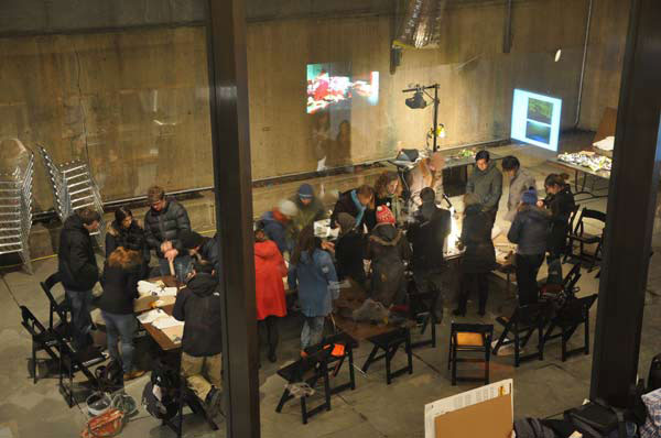
Balloon Mapping Training Class
The term ‘civic science’ has been used to describe science “that questions the state of things, rather than a science that simply serves the state” (Fortun and Fortun 2005: 50). Too often in the history of science, and particularly in environmental health science, researchers have distanced themselves from the researched. Particularly in disciplines such as toxicology, laboratory based research and epidemiology have favored the socially and economically powerful (Murphy 2006, Allen 2001, Fortun and Fortun 2005). PLOTS attempts to develop alternative dynamics and processes for research and development around environmental health issues that enable non-specialists to get involved in -- and even direct -- the questioning of ‘the state of things’. As we grow and our work becomes better known, PLOTS has been also begun receiving requests to help “serve the state” by working with international NGOs such as the World Bank and UNICEF. These agencies seek to apply community balloon mapping and other participatory approaches to help state agencies and NGOs develop responses to disaster relief. In an attempt to reconcile or at least understand the differences between approaches such as these, the PLOTS community has begun to articulate and debate how to situate our technologies in a framework of ethical and civic practices. Central to refining our approach to ‘civic science’ is the need to go beyond simply finding and supporting "users" of tools, to the development of what might be termed ‘recursive publics’ -- where the community is aware of and works continually at refining the structures that bring them together (Kelty 2008).
Political technologies in a growing and diverse community of practice
Barbara Marcotte, a Gulf Coast resident, made a striking comment about the importance of local involvement and knowledge in post-disaster projects that resonates with Public Laboratories vision of community engagement and leadership:
“listen to the people that have been down here, lived here, fished here, and camped here their whole entire lives
and even their parents lives, for generations. Because they know how these waters are, they know how the tides
come and go, they know how the storms affect this area, they provide a lot of valuable information and a lot of
valuable ways that people can accomplish what they want to do without destroying the things that we do...
The local collaborators which make up the Gulf Coast PLOTS community have pushed us to deepen our engagement in the region, to generate community discourse around our technologies, and to support local practitioners who have contributed in a sustained fashion to our shared civic science investigations. Mappers in the region have been excited about the potential of the tools to help them generate new data which they may use to contest official or corporate accounts of the effects of the BP spill.
Beyond the project sites started by PLOTS staff, new and independent projects and chapters have begun to flourish. A growing number of people have learned about our work from our website and media coverage, and have adapted and applied the techniques we've published to produce aerial imagery, as did Don and Justin Blancher, who emailed us out of the blue, asking what to do with a complete set of images of Perdido Point, Alabama. Some have become regular contributors to our mailing lists and website, such as Pat Coyle, who has posted not only aerial photos but videos offering documentation and improvements on balloon mapping rigs, or Michele Tobias, who has contributed instructions on making cloth ground targets to better align maps. Others have simply published their work online, leaving it to us to get in touch or try to make the connection back to our core community.
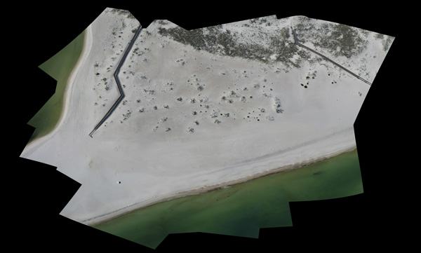
Perdidio Point Alabama, community-mapped by balloon.
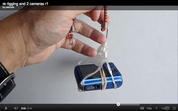
Photo from Pat Coyle's how-to video.
International development NGOs such the World Bank and UNICEF are also extremely excited about the possibilities for PLOTS tools in disaster relief, but they offer a very different model for our engagement and a different approach for building relationships with local residents. Both the World Bank and UNICEF have reached out to PLOTS as an organization, rather than a community, to assist in building relationships with communities at the grassroots level, and in some cases to help them leverage participatory processes in the collection of key disaster preparedness geodata for use by governments such as those of Togo or Brazil.
With our focus on building local capacity and expertise, we were surprised by the interest of the international development community in our work. PLOTS aims to empower communities with scientific tools that allow them to engage productively with technical, bureaucratic and economic forces shaping their social, environmental, and political development. The international development community’s work, on the other hand, has been described by anthropologist Jim Ferguson as an “anti-politics machine” (1994). Based as they are on neo-liberal economic theories, Ferguson argues, organizations such as the World Bank tend not to overlook the social and cultural politics in ‘developing’ countries but to actively evacuate them from decision making and program processes in order to frame such populations as pre-capitalist. By focusing on economic development and partnering primarily with governments, rather than citizens, international development NGOs can ignore and actually threaten solutions developed by communities in response their local social and economic inequalities. (Ferguson 1994) The risk of disrupting local social and political systems in a top-down ‘deployment’ of a foreign technology made us wonder whether the social practices of the Grassroots Mapping community could indeed be adopted in the context of either the Togo or Rio projects -- as envisioned by the World Bank and UNICEF. Organizations such as these typically use maps in their traditional role as instruments for organizing action at a distance. The World Bank, for example, needs geodata to perform “probabilistic risk assessment” for centralized response to flooding and to respond to the effects of climate change -- in a manner structurally similar to the origins of the modern practice of mapping in the European need to recognize, administer, defend and colonize territories (Burrnett 2000).
Grassroots mapping attempts to invert this dynamic by using maps as a mode of communication and as evidence for an alternative, community-owned definition of a territory. In our projects to date, our tools have been used to contest official maps or rhetoric by enabling communities to map sites that are not included in official maps. In Lima Peru, members of an informal settlement developed maps of their community as evidence of their habitation, while on the Gulf Coast of the US, locally produced maps of oil are being used to document damage that is underreported by the state. The maps UNICEF and World Bank would like local residents to produce have the potential to become the “official version”, either in the absence of alternative sources of data at the needed time or resolution, or because of the close relationship large NGOs have with local governments and their fluency in the requisite geographic information systems. Could our community centered practice of developing maps have a lasting effect on the usage, representation and access to maps in these places? How would communities, NGOs and local governments reconcile their competing perspectives of the territory in question, and which would be represented in a resulting “official” map?
Beyond these potential risks and rewards, one reason we did not immediately dismiss the requests for collaboration from international development organizations was that they represent an opportunity for locally produced data to gain credibility through association (as cynical as that sounds) -- and for local mappers to have “a seat at the table” in the kind of GIS transactions which have direct consequences for their communities. But can ‘civic science’ and PLOTS span the gulf between grassroots environmental justice work and governmental or “official” science? What can and should be PLOTS’ role in supporting either local residents or even government aid workers in the production of maps of, for example, “pacified” favelas in Rio de Janiero -- or indeed what can and should be our role (and our relationship to NOAA, BP, local/state/federal government, or to fishermen) in collecting and interpreting evidence of the BP oil spill?
Black boxing and situated learning
An added problem is that thus far, international development NGOs have pressured PLOTS to work at very short timescales -- to fly in, teach a course in a few days or weeks, and then leave. We argue that this is just one example of how such organizations conceptualize Grassroots Mapping as primarily a set of technical practices and technologies (the smaller box in figure 1), that can be passed from experts to trainees without providing time for the development of shared norms or cultural meanings around the tools. Anthropologist and historian of technology and science Bruno Latour famously argues against such “black boxing” of technology (1987), since when a technology is black-boxed, users are not first asked to consider how it was developed, who created it, and why. This approach is in direct conflict with the kind of methodological transparency we advocate in the PLOTS community. Although we do carefully refine technologies to make them accessible, we have so far resisted the temptation to sacrifice legibility for ease of use.
Often an elegant solution can meet both goals; for example, many of the complex concepts and practices required to produce aerial maps is embedded in the process of creating those maps by hand, and from the ground. The effect of noontime sun on image exposure, or the scattering of blue light by humid air -- both are legible phenomena to mapmakers who experience capturing imagery at different times of day or at different altitudes. Most evidently, the presence of images of the mappers themselves within the map -- or their boat or a vehicle of known length -- make the calculation of ground resolution straightforward while highlighting the authorship with a kind of signature. Mappers have jokingly suggested holding up today’s newspaper while mapping to note the date of capture. Through practice, Grassroots Mappers develop a situated understanding of the limitations of aerial image data, issues of privacy and the social and political power relations embedded in the practice and its products.
Conversely, university-level GIS and remote sensing classes often treat image data as a “given”, glossing over its production not only as the result of a military-industrial (and especially extraction/petrochemical-industrial) complex which has optimized the design of satellite imaging platforms and associated image processing methodologies for mineral and petroleum discovery. Such abstraction obscures how it is politically or socially constructed (Latour 1987). But even methodologically important details about the image capture process can be opaque to students without the kind of situated learning which DIY mapping offers. This is even more pronounced for the many users of Google Maps and Google Earth who need no prerequisite understanding of satellites, their orbits or design, their ownership, the data’s preparation or the legal or financial arrangement Google has with the imagery’s provider. While they can browse a bewildering quantity of imagery, they are fundamentally passive, disembodied observers. In general, the black-boxing of technologies encourages individuals to assume the role of user rather than that of producer, and black-boxing is linked to professionalization because expertise is then required to fix or modify the tool. Historian of technology Langdon Winner (among others) argues we should view technology development and technologies themselves as a process which creates particular social and political relationships -- sometimes unwittingly (1980).
The use of technology to make political and social distinctions is obfuscated by the formalization of expertise, preventing broader participation in technology development and the sciences. This practice pervades the health and environmental sciences where particular kinds of expertise are required to make maps, identify and speak about health hazards (Murphy 2004, Allen 2001, Fortun 2005). While some specialized knowledge might be required to perform these practices, that specialization often prevents community involvement in generating knowledge about their own conditions, there by removing them from important aspects of political, social and economic negotiations.
The question the PLOTS community faces is how to integrate into “grassroots mapping” the set of social and technical practices that encompass the larger context shown in Figure 2 (below) and to avoid reductive technology-centric conceptions of the practice. Inspired by the critique within anthropology and history of science that the retreat of health sciences into laboratories has made environmental justice and environmental health issues harder to study (Murphy 2006, Allen 2001), PLOTS attempts to design environmental health research tools with different embedded politics. PLOTS tools are ideally affordable, self-made or “DIY” and end-user modifiable. Public Lab engages communities to become researchers themselves, generating and interpreting their own data and actively developing and modifying their tools.
The next two sections discuss tactics and strategies we are developing to promote a broader view in the PLOTS research community of both technology and science; one which situates each in political and social meanings. Central to this experiment is the creation of a civic science with an emphasis on “recursion”, making it possible for users to become developers, teachers, and participants in creating not just knowledge, but tools and practices themselves.
Wrapping technology in participatory dialogue
As mapping projects have progressed, we've begun to refocus our efforts on the post-mapping stage, which consists of two parts. First, images are sorted and stitched together into a geographically referenced image, compatible with GIS software and viewable as an overlay on other map data such as Google Maps. Second, this data is published online and/or offline, with annotations and commentary by those who flew the balloon or kite, and from those involved in the preparation of the data and the process of making a map from the raw imagery. Both of these documentary practices situate the map production and provide a space for the development of dialogue around the new data.
Field notes and cartographer notes provide personal insights and historical context of environmental and social issues that cannot be distinguished in aerial imagery alone. From a Chandeleur Islands map, with images captured on May 9, 2010, fieldnotes by Stewart Long, who helped bring Grassroots Mapping to the Gulf Coast, yielded the following insights into the process of image collection and the information found in the map:
“While it was windy at times, the team found calm ballooning-friendly conditions at mid day when the flight took
place. The chemical dispersants were most dominant from our ground perspective while out along the
Chandeleur. It was a chemical smell that I was not familiar with, something like gasoline fumes.
The balloon flight drifted along with the boat for about a half hour of continuous shooting inside the Chandeleur
barrier island chain. While we observed visible oil and chemical dispersants in the water during the whole time
we were out there, the extent of the mapping area was determined by the presence of ground control among the
aerial images and GPS tracks.
This map is of an area in the Chandeleur where a cut has formed in the barrier island landform. There is visible
reef rock, sand bar, and sand spit. The rainbow color is visible oil sheen on the surface of the water. There is
also heavy oil pollution within the sand pit, and in the wave action along the sandy beach. Brown Pelican (LA
State bird) and Sandwich Tern are identifiable in the SE portion of the map.” -- Stewart Long

Balloon-mapped picture of Chandeleur Island, Louisiana map with birds, plume, ground photos.
Click on image to open larger picture.
Field notes as well as ground photos have contributed valuable contextual data about what mappers experienced as they explored and documented miles of shoreline during the spill. The following note was contributed by Erin Sharkey, a Grassroots Mapping trip leader, during a mapping of Ocean Springs, Mississippi on June 18, 2010:
"The beach at Biloxi was very pretty and pristine. It did not appear to have been touched/affected by the oil yet. We did find an odd pool of what looked like oil at Lat 30.40/Long -88.83. Also, we found hundreds of dead
hermit crabs washed ashore at our second location and a few huge dead fish.
No trouble getting to the site. However, when tried to fly the kite on the beach next to a marina next to the Hard
Rock Casino, a security guy drove his golf cart to us to tell us that some of the boaters were worried that our
kite would ‘fall on their boats’ since the kite kept flying away from where we wanted it, we just reeled it in and left."
This approach of adding layers of contextual information to aerial mapping differs from our initial focus of simply helping people to collect imagery and create maps. We’ve begun advocating for mappers to examine the social and political contexts in which they collect data, incorporating local-level discourse even before we begin the technical collection of data and imagery. With this in mind, we have adapted some of the recommendations of the excellent “Practical Ethics for PGIS Practitioners, Facilitators, Technology Intermediaries and Researchers” by Rambaldi et al:
-
What does the existence of new imagery for this area imply with regard to security, privacy, and exposure for the community?
-
Who is included in this mapping attempt, and who is under-represented or absent?
-
Whose map will this be and for whom is it?
-
What are some ways to allow or limit access to the data?
-
Does the production of this data expose the community to different kinds of risks or benefits?
-
How might those risks be mitigated and those benefits leveraged?
These are excellent points to consider and are even more pertinent given that the kind of data -- aerial imagery in GeoTiff format -- are potentially more legible to those in power than the formats PGIS practitioners often produce with communities. Instead of hand-drawn or GPS-based vector maps, we are creating raster data in a format identical to that produced by satellites, a factor which may account for the increased interest from parties such as the World Bank.
Local Versioning
Over the course of each project, local mappers have begun to develop their own adaptations and improvements to the basic balloon and kite rigs. These regional variations are some of the strongest evidence that tools are not only being adopted, but that mappers are becoming experts in their own right -- incorporating local knowledge to adapt tools to challenging new scenarios. Some changes, such as the occasional Gulf Coast use of marsh grass or fish vertebrae as spacers to depress the camera button, come with a certain regional pride; other variations -- like the use of boats to tow kites in the absence of wind -- have been shared “upstream”, to use the vocabulary of open source software development. That is, other regional groups have watched and learned new practices through photographs, blog posts, and phone conversations, as well as during visits between groups.
Local versions help to assert local ownership not only over the data collection process, but over the very development of civic science technologies, and is an encouraging sign of the kind of “recursive” public we had hoped to foster. These small improvements speak not only to the growing expertise of individuals in constructing their own research tools with locally sourced materials and a deep understanding of local conditions, but they also demonstrate that the technology is far from mature, but is in fact constantly being reconfigured by its users to meet new scenarios.
Local mapping groups have even rejected new improvements from other members of the PLOTS community, such as the experimental Mylar balloons which have gained popularity in the Gowanus Canal. Despite the lower cost of a Mylar balloon, the Gulf Coast team continued to use five and a half foot chloroprene weather balloons because of their durability and UV resistance. While the same Gulf Coast team developed waterproof plastic stabilizing wings and an elegant way to construct them from spare strips of the same soda bottle used to protect the camera, west coast mappers typically do not use stabilizing wings, preferring to stabilize the camera by simply taping it to the tether.
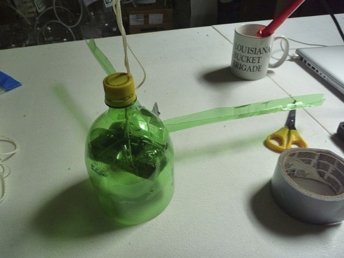
Cesar’s soda bottle rig, From a Louisiana community mapping project.
These examples of a basic tool design being transformed into locally reproducible versions are among the greatest successes of the PLOTS research community. The ability to respond to one’s environment, source local alternatives (whether at a store on the way to mapping site or on a boat in the middle of the wetlands), and create a tool that is better suited for one’s environment, demonstrates the ability of a DIY approach to successfully link local expertise with technological production.
To support this kind of “local versioning” of PLOTS tools, and to enable more cross-seeding of ideas and approaches amongst members of our research community, we’ve begun planning “barn raisings” around tool development and pop-up Public Laboratory projects. The idea of these events, named after the 18th- and 19th-century rural American practice where a number of families collaborate to construct a barn, is to bring together a group of around 25 participants with a diverse range of expertise to collaborate on a specific DIY tool. The first barn raising was held on October 21-23 2011 in Asheville, NC, and was focused on developing an affordable infrared camera for aerial vegetation assessment.
The Grassroots Mapping Forum and the Public Laboratory Archive
Public Laboratory has found itself in a position to build a deeper capacity for developing new methods in civic science participatory engagement. Two of the outcomes that we aim to establish in all Public Laboratory aerial mapping projects going forward are making use of our online Public Laboratory Archive, and the printed map series known as the Grassroots Mapping Forum that both integrate our approach to participatory, discourse based practices in map making.
The Archive fulfills several goals; one is to support the legitimacy of locally-sourced data by presenting it in formats which are legible to the traditional scientific establishment, and ensuring that the data can be correlated with more traditionally-collected data, such as that of the United States Geological Survey, for example. To create an ease of accessibility to the PLOTS digital collections in areas where Internet is either not consistently available or a choice tool for residents, we are additionally creating archived digital collections of images and maps from each regions, compiling them on data sticks and DVDs and archiving them as part of local library collections in communities such as Belle Chasse and Buras, Louisiana.
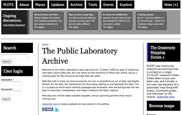
Public Laboratory Archive Page.
Click on Image to go to the archives.
http://publiclaboratory.org/archive
PLOTS launched the first Grassroots Mapping Forum, sponsored by Development Seed, in June 2011 when we published a fold-out newsprint publication that featured a July 2010 map of part of Wilkinson Bay, Louisiana on one side and content such as a interview with resident Barbara Marcotte, an article on data lifecycles, the five page grassroots mapping guide and a mono-tone version of the map on the front that people can take with them when in the Wilkinson Bay area and write in ground observations that can be sent back to Public Laboratory and added as a layer on the July 2010 map. Additional benefits of the paper format include the fact that it is very difficult to share digital maps in the outdoors, on boats, or on beaches, whereas paper maps (especially laminated ones) are well suited to such conditions.
In developing the monthly publication, which will be available for use by all Grassroots Mapping sites, we are creating a reverse process in which the forum is not simply an outcome, but starts before the image collection and map stitching begins and acts as a guidepost for the entire process. Using guidelines and community engagement principals developed to address the unique situations of each community we work with, we are focusing in on requested deliverables that can appear on each forum so as to enable critical engagement in local environmental and social issues by locals and non-locals. The goal of the forum is to create a compelling picture of the cultural history and landscape that accompanies the physical topography seen in aerial images which participates in and expands a continued critical discussion within the broader PLOTS community.
The idea for the Grassroots Mapping Forum arose as we watched the differences in use between digital and analog media in each community- what type of navigation systems people preferred in the intricate Louisiana wetlands, the access to cell phone signals, how people keep personal and business records, preferred methods of data production, and what types of images and news sources were preferable- print or digital. With an overall concentration on developing technological and media based solutions to each of our problems, creating the Forum allowed us to call on the still popular print media used in Southern Louisiana, creating a coexistence between the technologically developed Archive and digital collections of Grassroots Mapping and traditional print journalism pieces that can be dropped off at seafood markets, libraries and marinas for quick access to information.
A DIY Forum
Just as we advocate the construction and use of local versions of civic science tools, the Grassroots Mapping Forum affords an opportunity to develop a broader practice of developing discourse around mapping projects, and offers an example of a print format to achieve this. Since the publication of the first Forum, other aerial mapping projects have begun to develop print publications around the data they have produced, and we have begun to promote the production of local, “DIY” editions of the Forum for every project our community attempts. This is one of the first steps in developing a literature around our community of practice in order to legitimize and refine our approach and the data it yields.
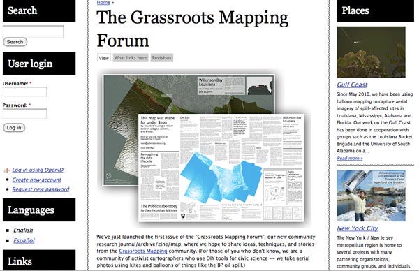
Public Laboratory Grassroots Mapping Forum Page.
Click on Image to go to the archives.
http://publiclaboratory.org/forum
Widening the definition of a “Grassroots Mapping project” to encompass such a publication -- beyond merely the act of creating the data -- affords mapmakers an opportunity to develop discourse and next steps focused on the issues they care about, using the new data as a platform. By helping to disseminate the new information and by grounding new discussions about local issues in the insights which new information can offer, mapmakers have more leverage to effect change with the data they have produced. This is central to our drive to engage people in producing, not just consuming, information.
By championing the printed map format as part of any Grassroots Mapping or Public Laboratory-derived project, we explicitly link technologies and their sociopolitical context at the local level -- a strategy which can help to re-focus projects which tend to abstract technologies away from organic communities of practice, like the UNICEF and World Bank initiatives. Ideally, “doing a grassroots mapping project” can be expanded to include engaging a community in dialogue about social and political issues surrounding the production of new evidence, and developing a public forum for that discussion. This “sharing back” is an important element of our version of civic science, and as in open source software projects, it is also inextricably linked to the legal framework we have built for intellectual property.
Ethics and open source practices
Most open source communities are bound together by their chosen open source licenses, and protected by them. These legal contracts protect the rights of the end-users to reuse, adapt, redistribute, and improve the technology (the “4 freedoms of free software” outlined by Richard Stallman), at the expense of the control of the originating author (though often to their overall benefit). This, among other advantages, allows many contributors to take part in the development of a complex system without the risk that the original author might exert exclusive control over the joint work or its applications. However, this shared ownership model is far from the only guiding principle of an open source community. Most open source projects rely upon strong shared cultural norms, a distinct dialect and vocabulary, inside jokes and often a kind of frank or even brusque mode of conversation which can be off-putting or intimidating to outsiders. Kelty, a theorist of open source communities, has argued that discussions about licensing, “forking” of open-source projects and the cultural norms around open-source participation have enabled such communities to become recursive -- aware of and continually revising the structures that bring them together. PLOTS is learning from and attempting to cultivate such recursive participation in our own ‘civic science’ research community.
As both individuals and as a community, we stand to benefit from the legal protections of open source licensing, but more importantly, we are attempting to create a culture of critical inquiry and discourse to link technologies with their social context. By exploring and debating topics like the ethics of data production, the importance of high-level participation in research projects, and the socioeconomic and political dimensions of our work, we hope to equip ourselves as a community with the necessary frameworks to assess political. social, and ethical questions in the diverse applications of our tools in the field.
ShareAlike/Copyleft
Many open source licenses go beyond protecting the four freedoms of free software to include a more stringent rule requiring any adaptations to be released under the same open license -- a provision known as copyleft, or ShareAlike. This requirement, which Public Laboratory has adopted for most of our technologies, legally obligates “downstream” users to contribute back their improvements and changes -- which we define as extending not only to the tools but the practices and narratives which surround them. More explicitly, we ask any party, be they an individual or an organization, to write about and share the uses they found for the tools, and to present their works to the public, and especially to the rest of the PLOTS community, on our website.
This policy has already begun to bear fruit: Felipe Heusser Ferres of Ciudadano Inteligente adapted our Illustrated Guide to Grassroots Mapping with Balloons and Kites, translating it into Spanish and adapting it as a single page quick-reference sheet with sleek graphics. Aimed at Chilean activists, it cites prices in Chilean pesos and makes additional suggestions for the use of live video broadcasting from a smartphone. Pat Coyle’s documentary videos on balloon mapping, Michele Tobias’ careful documentation of infrared beach vegetation mapping are other good examples where contributions are not merely using the PLOTS site as a convenient blog-like publication venue, but actively contributing to a shared body of research. Users of the PLOTS website must agree to adopt a Creative Commons ShareAlike license, and so their work in turn is explicitly available for modification and reuse.
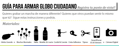
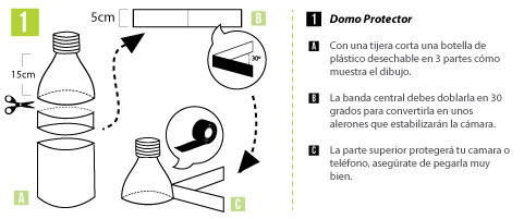
Instructions for Balloon Mapping for Chile
ShareAlike is important not only as part of our stance on participation, but in the partnerships we form with more traditional organizations. These licenses require our partners, such as traditional academic research labs, universities, and even commercial enterprises to participate in the same give-and-take of information -- something which many of these organizations are not in the habit of doing -- especially with “non-expert” collaborators. In our partnership with the Louisiana Universities Marine Consortium, we were able to publish significant portions of their raw data for an area of Barataria Bay, Louisiana, under a Creative Commons Attribution license, in exchange for opening up our own data. Beyond the potential to develop shared interpretation and publication of that research, legitimizing our data-collection technologies, this is an excellent example of the tactical use of open source licensing as leverage to open up processes to which the public may not have access.
As most of our members are not from the software world, we have striven to establish a culture of shared authorship and cultivating a reflex for contributing ones' changes back to the community in this way has been one of our greatest challenges. Some members of our community seem reluctant to voice opinions or offer advice in a public forum, perhaps due to a perception that they “are not scientists”—despite the fact that in many cases they are producing data whose precision and quality far exceeds that of many of their peers from traditional scientific institutions. However, that many have begun to assert their expertise indicates an awareness on their part that they are not merely an audience. From another perspective, to so openly share techniques and data is to yield some degree of control over the direction of development and indeed the end uses of the technology. The latter has been of some concern to our core community.
Mapping protest
One of the reasons we find map making to be a powerful tool is that it introduces new information with the potential to change how a community, a place, is perceived. Most recently, Public Laboratory partnered with Fundacion Ciudadano Inteligente in Santiago Chile, which produces web technologies to support citizen participation and government transparency. Throughout 2011, students organized protests in Chile calling for new educational policies. In an adaptation of Natalie Jeremijenko’s 2004 BIT Balloon project to document protesters at the Republican National Convention in New York City, Ciudadano Inteligente introduced the practice of “protest ballooning”, launching an iPhone-equipped video streaming balloon which protesters could carry with them. Working with a small amount of money from the Knight Foundation, protestors began broadcasting narrated live video feeds, attracting an online audience of over 10,000 on their first attempt. Felipe Heusser Ferres of Ciudadano Inteligente reports that, “Documentation like this allows us to show, when the government tries to downplay the size of the protests from 100,000 to 60,000, just how many people did participate.” Taking inspiration from the Santiago protest mappings and Jeremijenko, Hagit Keysar and Shai Efrati worked with Jeffrey Warren in the summer of 2011 to map thousands of demonstrators marching across Jerusalem in support of Palestinian independence. Even more recently, activists with the OccupyWallStreet movement have begun to employ balloon mapping to promote their activities in lower Manhattan.
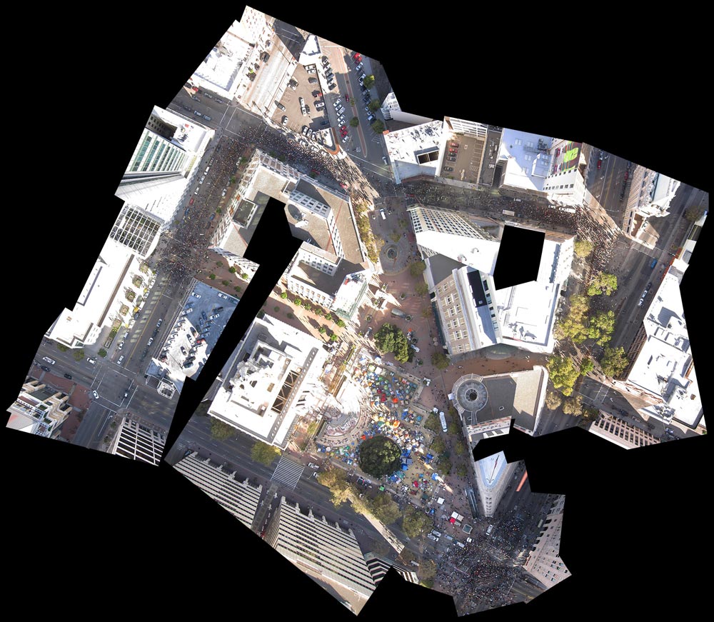
Occupy Oakland, Balloon Mapped
Click on picture to open view expanded image.
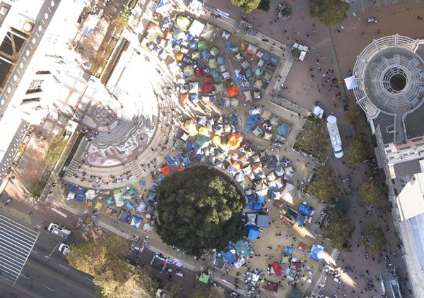
Occupy Oakland, Balloon Mapped, close-up.
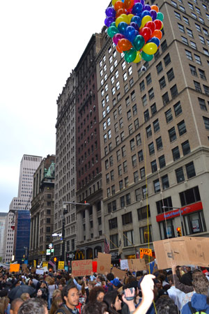
Occupy Wall Street, in the process of being balloon-mapped.
This flurry of protest ballooning projects raises a set of ethical questions, ranging from the use of high resolution imagery in which individuals might be identified, to questions of how to engage in shared research on such politically engaged technologies in a community with diverse political beliefs. A central ethical issue which has emerged is the balance between the desire to open-source map data, and the need of vulnerable communities to maintain control over representations of their territory. In some cases, an argument can be made that open source data provides a minimum of parity -- that, for example, in the West Bank and Gaza, as Mikel Maron points out, the Israeli Defense Force already has high resolution geographic data far exceeding of what a local community has access to. To support and enable the production of an alternative, public data set is, far from redundant, to neutralize the privilege and power of that exclusivity of information by making an equivalent data set public.
Paper for privacy
Still, despite our preference for open source, ethical concerns can override our community’s desire for transparency. The delicacy and volatility of political and social contexts can merit caution when deciding whether to release mapping data publicly. In these cases, a print-only edition can provide a measure of data privacy for more vulnerable communities. In Cantagallo, an informal settlement in Lima, Peru, mappers did not produce a georeferenced digital edition of their map; residents did not choose to use it as a means of communication with GIS-enabled entities such as the Municipality of Lima. Likewise, neither an online version nor a precise knowledge of the map’s relationship to global geographic references were as relevant to local residents as a paper map which could be rolled or folded, shared on a table amongst a group of people, or posted in a public place.
In a Palestinian neighborhood in East Jerusalem where Grassroots Mappers assisted youth in producing the highest resolution documentation of their territory known to date, the broader publication of aerial surveys presented a possible risk to participants. While there is publicly available aerial photographic data of the same area from sources such as Americans for Peace Now, an important meaning of the workshop was that this map was made by residents, of their own homes. This same fact of authorship could provoke unwelcome interest from the Israeli government, and so in order to avoid adverse consequences for the map’s creators, it was kept behind password protection and circulated only within the community, primarily on paper.
These kinds of sensitivities to context and local politics and culture which can easily become lost if our technologies are not accompanied by a well situated framework of norms, ethics, and a critical eye toward the risks and opportunities they present. These ideas are central to the kind of discussions we hope to cultivate in the Grassroots Mapping Forum, and on a local scale, in any local edition of that format. It is our hope that the Forum, the strengthening of our community of practice it provides, and the ShareAlike provisions which protect our technologies and the practices which develop around them will provide a measure of control over what the technology is used for -- a byproduct of building discourse around acceptable and ethical practices which is not legally binding, but carries a strong moral burden.
Conclusion
One of the most powerful aspects of the design of our tools is that they specifically select methodologies which scale horizontally rather than vertically; that is, while it would be impractical and inefficient -- both in labor and technology -- for Google or a national government to use balloons and kites to map large areas, such an approach is eminently scalable for small communities and individuals. The transfer of these practices is also most easily achieved in-person and on-site, through personal interactions and collaborations -- as opposed to from polar orbit. This horizontal “design feature” tends to preference public and participatory use by small communities, but as we have learned in our discussions with UNICEF and the World Bank, this is not always so simple.
On July 6, 2011, a Houston-based policeman contacted PLOTS asking about the potential for using balloon mapping to monitor crowds at public events. The similarity of the request was striking -- Ciudadano Inteligente had just begun their Chilean protest self-monitoring and in Jerusalem we were preparing a balloon rig for protests the following week. The equipment -- if the Houston police department followed through with their plans -- would likely be almost identical, but the meaning of such a map was, in our eyes, fundamentally different, originating as it would on the other side of the inherent asymmetry of power that exists between government and the public. Is a police department considering such an attempt to be a “Grassroots Mapping project” a failure on the part of our community to convey a sense of our technology’s context, or its political and cultural meanings? We questioned.
While we declined to participate or collaborate with this particular inquiry, it emphasized the need to clearly situate our technology as an alternative to government and corporate information production, and to draw explicit attention to our work as a grassroots community of practice who are offering a critique of traditional map making. The responsibility for developing strong ethical norms and exploring potential risks must be addressed both before, during, and after the development of accessible technologies.
We don’t have final answers to the pressing questions continually raised through our work, but as this paper aims to illustrate, we are experimenting with a range of social, legal and technical practices that work against pressures to ‘black box’ PLOTS tools. These include a focus on the establishment of autonomous and “recursive” local mapping chapters made up of local residents, the development of events, media, and literature which situate the technology and the data it produces in relation to local issues and practitioners, and the cultivation of a forum where local experts can exchange and debate practices and collaboratively develop technologies and interpret results. Ideally our community does not develop “one size fits all” solutions, rather we cultivate situated scientific tool use and development to create a spectrum of public lab spaces and products adapted to and querying the state of their individual environments. PLOTS version of civic science encourages rather than reduces the diversity of human social and environmental experience by creating horizontal and recursive data sharing, analysis and production practices to generate an evolving tool kits for communities to begin questioning and investigating their environmental and social conditions.
Bibliography:
Allen, Barbara. 2003. Uneasy Alchemy Citizens and Experts in Louisiana's Chemical Corridor Disputes. Cambridge, MA: MIT Press.
Burnett, Graham. 2000. Masters of all they Surveyed: Exploration, Geography and a British El Dorado. Chicago: University of Chicago Press.
Ferguson, James. 1994. The Anti-Politics Machine: "Development", Depoliticization, and Bureaucratic Power in Lesotho. University of MN press.
Fortun, Kim and Michael Fortun. 2005. Scientific Imaginaries and Ethical Plateaus in Contemporary U.S. Toxicology. American Anthropologist 107 no. 1:43-54.
Kelty, Chris. 2008. Two Bits: The Cultural Significance of Free Software and the Internet Durham: Duke University Press.
Latour, Bruno. 1987. Science in Action: How to Follow Scientists and Engineers through Society. Cambridge (MA): Harvard University Press.
Rambaldi, Giocomo, et. al. 2006. Practical Ethics for PGIS Practitioners, Facilitators, Technology Intermediaries and Researchers. Participatory Learning and Action, 54, April 2006.
________. 1990. Drawing Things Together. In Representation in Scientific Practice. ed. Michael Lynch and Steve Woolgar. Cambridge, MA: MIT Press.
Murphy, Michelle. 2006. Sick Building Syndrome and the Politics of Uncertainty: Environmental Politics, Technoscience and Women Workers. Duke University Press.
Winner, Langdon. 1980. Do Artifacts Have Politics? Daedalus, Vol. 109, No. 1, Winter.